 Loading... Please wait...
Categories
 New Products
-
 $10,900.00
-
 $16,900.00
-
 $7,950.00
-
 $2,690.00
-
 $14,290.00
Our Newsletter
- Home
- 3D Laser Scanner
- FARO Orbis Mobile Scanner and Datalogger kit
FARO Orbis Mobile Scanner and Datalogger kit

Product Description
For sale New FARO Orbis Mobile Scanner and Datalogger kit with affordable price USD $19900.00. Please contact us for ordering information. All prices are subject to change without notice, except that prices for an order that have been accepted.
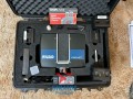
FARO Orbis is a unique mobile scanning solution created to optimize workflows and elevate productivity. Designed for construction, engineering and surveying professionals, Orbis delivers rapid speed of capture, while returning highly accurate 3D visual representations of the real world. Integrating FARO’s Flash Technology™ in Orbis allows for stationary scans in just 15 seconds and provides unrivaled detail from a mobile mapping solution.
Powered by GeoSLAM’s proprietary SLAM algorithm, it’s the evolutionary step for industry professionals looking to provide highly accurate deliverables faster, reduce human error and magnify overall efficiency. Embrace the power of hybrid mobile scanning with stationary Flash scanning capabilities and embark on a new journey to transform your projects with Orbis – the ultimate companion for modern scanning challenges.
Hybrid Reality Capture with FLASH Technology
Improve your mobile scanning quality with Hybrid Reality Capture powered by FARO’s proprietary Flash Technology. Previously unseen in a mobile scanning solution, Orbis offers mobile scanning and stationary scanning capabilities with Flash, delivering high quality, accurate, and dense datasets. It’s a combination of speed, data clarity and accuracy in one complete scanning solution.
10x Faster Than Other Surveying Methods
Experience unmatched speed of data capture with mobile scanning technology. Designed for rapid deployment, Orbis ensures fast and accurate data acquisition, revolutionizing your project timelines. It empowers users to capture detailed and accurate spatial data 10x faster than traditional laser scanning, accelerating workflows and ensuring you stay ahead in today’s fast-paced world.
Frequent Data Capture for Better Insights
Capture 3D data more frequently and comprehensively than ever before and elevate your data insights. Stay up to date with fast-paced and evolving scenarios like construction progress, enhancing decision-making and improving collaboration. Ease of use and portability make frequent data capture possible, without impacting jobsite production – a constant stream of fresh insights to transform your projects and deliverables.
Scanning Doesn’t Need to be Complicated
Designed with usability in mind, scanning with Orbis is as simple as pushing a button and walking with the device. It simplifies complex surveying tasks, enabling efficient data collection for a broader audience, across various industries. Expanding the opportunities for data capture in previously unobtainable places.
The World’s Leading SLAM Algorithm
GeoSLAM’s proprietary SLAM algorithm drives Orbis and has been tried and tested in some of the most difficult environments, for over a decade. Constant innovation from customer input has led to the SLAM algorithm that continues to deliver and improve customer projects, in a myriad of industries.
One Year Warranty
We design, build and test our products with quality as a top priority. Because we believe in our hardware, Orbis comes with a one-year warranty as standard. We also offer affordable extended service plans, so you can have peace of mind and prevent unexpected expenses.
FARO Orbis Features:
Lightweight and Easy-to-Use
Weighing just 3.6kg, including the datalogger and battery, Orbis is ideal for scanning large areas fast, without large setups.
Higher Levels of Accuracy
A precision of 5mm during a mobile scan and 2mm during stationary Flash scanning makes Orbis the ultimate mobile scanning solution for high levels of accuracy.
Ideal for Internal and External Mapping
With up to 120 meters in range, Orbis is the ideal solution for both indoor and outdoor scanning, with the ability to seamlessly transition between both.
Best of Both Worlds Processing
Orbis offers local processing in the FARO Connect software or optional FARO Sphere® XG Digital Reality platform – flexible solutions for processing, analyzing and sharing data.
360° Photos and Colorized Data
The integrated 8-megapixel camera on the Orbis enables colorized point clouds and additional 360° panoramic pictures.
Engineered for the Toughest Environments
Engineered with the toughest environments in mind, Orbis has the capacity to map places like underground mines, dense forests or construction sites with ease.
The All-in-one Mapping Solution
The Orbis is compatible with a monopod for stationary Flash scanning, car mount for capturing larger areas, backpack for tough terrain, and cradle for descending into a mine shaft, it is truly an all-in-one solution.
APPLICATIONS:
AEC
The Perfect Tool for Repeatable Data Capture and Collaboration
To ensure your construction projects remain on track, it’s essential to review changes over time. Orbis offers a fast and accurate method of data capture, making it possible to analyze progress on a monthly, weekly or even daily basis without causing disruption to job-site activities.
Mining
Rapid Site Information for the Modern Mine
Orbis is an ideal tool for capturing both overground and underground data, thanks to its impressive rate of data capture and range capabilities. You can utilize it to capture stockpile volumetric calculations, production progress mapping, convergence analysis or vertical shaft inspection. By doing so, you effectively reduce risk to human life by limiting exposure to hazardous environments and optimize mining operations to yield better returns on investment.
Geospatial
A Faster Way to Capture your Data
Orbis offers a versatile scanning workflow, combining fast mobile scanning data acquisition with detailed static scans using Flash Technology. It excels in various applications, including geospatial workflows making it the ideal choice for tasks that demand flexibility and precision. Whether you need fast data capture in dynamic scanning or meticulous Flash scans, Orbis delivers outstanding results, accommodating a wide range of job requirements.
SPECIFICATIONS
System Overview;
FARO Orbis : Mobile scanner powered by GeoSLAM technology offering mobile and stationary Flash scanning in one device
FARO Stream : Mobile app for field operation of FARO Orbis and FARO Focus Laser Scanner
FARO Connect : Desktop processing software for FARO Orbis and legacy GeoSLAM mobile scanners
FARO Scene : Desktop registration software for all 3D reality capture data
FARO Sphere XG : Cloud-based platform for all reality capture data including FARO Orbis
Performance;
Range : 120m
Points Per Second : 640,000
Field of View : 360° x 290°
No. of LIDAR channels : 32
Camera : Full 360° image of 8M pixels captured every second
Mobile Scanning;
Precision : 5mm
Trajectory & Mapping : Robust SLAM powered by GeoSLAM technology
Settings : Automatic Standard and Preset Processing Environments
Stationary Flash Scanning;
Precision : 2mm
Duration : 15 sec. including color
Resolution : 19M points (13mm @ 10m)
Registration : Real Time and Fully Automatic with GeoSLAM technology
General Specifications;
Environment : Indoor and Outdoor
Laser Class : Class 1, Eye Safe
Weight : Scanner: 2.10kg, Datalogger: 0.95kg, Battery: 0.55kg
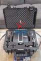
Transport Case Dimensions : 500mm x 625mm x 250mm
Operating Temperature : 0° to +40°C
Manufacturer Warranty : 1 Year
Operation;
Stand-alone Operation : One button to start/stop data capture; One button to capture Flash scans
Smartphone Operation : FARO Stream app (for iOS and Android): scanner control, real-time data visualization, and direct sync to cloud processing with FARO Sphere XG
Control Points Capture : Stop-and-Go, checkerboard, reflective, and spherical targets for alignment and/or georeferencing
Advanced Registration : When desired, register multiple mobile, Flash and/or FARO Focus scans
Configuration : • Handheld with Datalogger on Shoulder Strap
• Monopod with Scanner and Datalogger mounted together
• Accessories available: Car Mount, Backpack, Cradle
Scanner Orientation : Can be used in any orientation: upright, upside down, sideways
Battery Duration : Typical 3 hours
Internal Storage : 512 GB, up to 50 hours of continuous data capture
Data Transfer: WiFi, RJ45 or directly with USB stick
Data/Processing;
Data : Point clouds with Intensity and Color, 360° Images, Trajectory
Raw Mobile Data Size : 350MB/min uncompressed
Flash Scan Data Size : 125MB
Desktop Processing : FARO Connect for Mobile and Flash Scans, FARO Scene for Advanced Registration
Cloud Processing : Fully automated with FARO Sphere XG
Output : Mobile scan: E57, LAS, LAZ, PLY, TXT -
Flash scan: E57
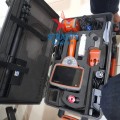
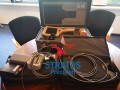
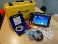
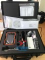
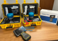
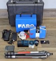
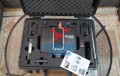
Package Includes:
- (1) FARO Orbis Mobile Scanner (Replacement handle P/NACCS-MNT-0031)
- (1) Datalogger
- (1) Datalogger Battery (P/N:ACCS-PWR-0030)
- (1) Battery Charging Kit(P/NACCS-PWR-0031)
- (1) Phone Mount (P/NACCS-MNT-0032)
- (1) FARO Orbis-Cable (P/NACCS-PWR-0032)
- (1) Quadlock
- (1) Datalogger Shoulder Strap
- (1) USB Flash Drive
- (1) Monopod and Datalogger adapter (P/NACCS-TRPD-0030)
- (1) Mobile Scanner adapter for the monopod (P/NACCS-MNT-0030)
- (1) Transportation case (P/NACCS-CASE-0030)
Warranty Information

Product Reviews
Customers Who Viewed This Product Also Viewed
-
 $16,900.00
-
 $6,000.00
-
 $4,000.00
-
 $23,900.00
Add to Wish List
Related Products
-
FARO Focus 3D X330 Laser Scanner $4,000.00
-
FARO Focus S350 Laser Scanner $6,000.00
-
FARO Focus Premium 350 Laser Scanner $23,900.00
-
-
 FARO Focus Premium 70 Laser Scanner $14,900.00